INS guidance relies on internal sensors like accelerometers and gyroscopes to calculate position, making it immune to external signal jamming but prone to drift over time. GPS guidance uses satellite signals for precise navigation, offering high accuracy but vulnerability to signal obstruction or interference, so combining both enhances your system's reliability and accuracy.
Table of Comparison
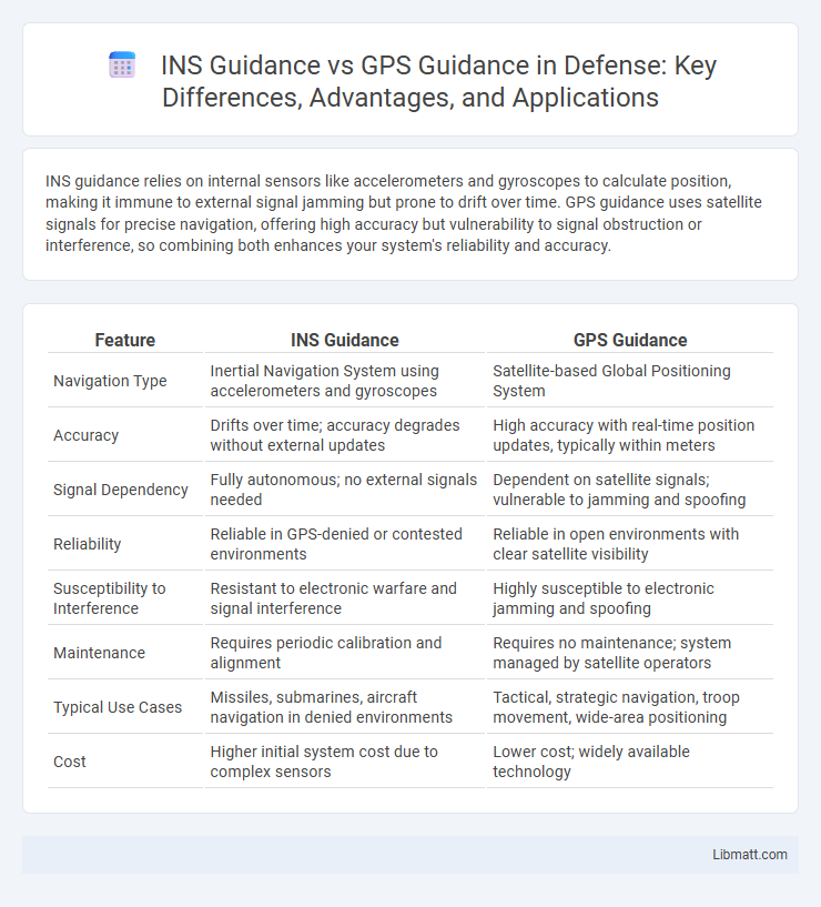
| Feature | INS Guidance | GPS Guidance |
|---|---|---|
| Navigation Type | Inertial Navigation System using accelerometers and gyroscopes | Satellite-based Global Positioning System |
| Accuracy | Drifts over time; accuracy degrades without external updates | High accuracy with real-time position updates, typically within meters |
| Signal Dependency | Fully autonomous; no external signals needed | Dependent on satellite signals; vulnerable to jamming and spoofing |
| Reliability | Reliable in GPS-denied or contested environments | Reliable in open environments with clear satellite visibility |
| Susceptibility to Interference | Resistant to electronic warfare and signal interference | Highly susceptible to electronic jamming and spoofing |
| Maintenance | Requires periodic calibration and alignment | Requires no maintenance; system managed by satellite operators |
| Typical Use Cases | Missiles, submarines, aircraft navigation in denied environments | Tactical, strategic navigation, troop movement, wide-area positioning |
| Cost | Higher initial system cost due to complex sensors | Lower cost; widely available technology |
Introduction to INS and GPS Guidance Systems
Inertial Navigation Systems (INS) utilize accelerometers and gyroscopes to calculate position by measuring the acceleration and angular velocity of a moving object, functioning independently of external signals. Global Positioning System (GPS) guidance relies on satellite signals to determine precise location coordinates through trilateration, offering real-time positioning data worldwide. Your choice between INS and GPS guidance depends on operational needs, with INS excelling in GPS-denied environments and GPS providing high accuracy under open-sky conditions.
Core Principles of Inertial Navigation Systems (INS)
Inertial Navigation Systems (INS) rely on accelerometers and gyroscopes to calculate position, velocity, and orientation by measuring the vehicle's acceleration and rotational rates without external signals. INS provides continuous, self-contained navigation data, making it highly reliable in GPS-denied environments such as underwater, underground, or during electronic interference. The core principles of INS emphasize inertial sensing, dead reckoning, and error correction through sensor fusion or Kalman filtering to maintain accuracy over time.
How GPS Guidance Systems Work
GPS guidance systems work by utilizing signals from a network of satellites orbiting the Earth to determine the precise location of your device. These systems calculate your position by measuring the time it takes for signals from multiple satellites to reach the GPS receiver, enabling accurate navigation and real-time route adjustments. Unlike INS guidance, which relies on internal sensors like accelerometers and gyroscopes, GPS guidance provides external location data, ensuring higher accuracy in open environments.
Accuracy Comparison: INS vs GPS
INS guidance provides continuous navigation data by measuring motion and orientation through accelerometers and gyroscopes, maintaining accuracy short-term but gradually accumulating errors over time due to drift. GPS guidance offers global positioning with satellite signals, delivering high accuracy typically within a few meters, but can be affected by signal loss or interference, especially in dense urban or obstructed environments. Combining both systems leverages GPS accuracy for long-term positioning and INS for short-term stability, enhancing navigation precision for Your applications.
Reliability in Challenging Environments
INS guidance demonstrates superior reliability in challenging environments due to its independence from external signals, maintaining accurate navigation through GPS-denied areas such as dense urban canyons, underwater, or inside tunnels. In contrast, GPS guidance depends on satellite signals, which can be obstructed or degraded by physical obstacles, atmospheric interference, or intentional jamming. Combining INS with GPS enhances overall reliability by leveraging INS's robustness as a backup during GPS signal loss or degradation.
Dependency on External Signals: Strengths and Weaknesses
Inertial Navigation Systems (INS) operate independently of external signals by relying on internal sensors like accelerometers and gyroscopes, making them highly reliable in GPS-denied environments such as underwater or in electronic warfare scenarios. GPS guidance depends on satellite signals, offering global accuracy but becoming vulnerable to jamming, signal loss, or spoofing in contested environments. Combining INS with GPS enhances overall navigation robustness by using GPS corrections to mitigate INS drift while maintaining operational capability when GPS signals are unavailable.
Application Scenarios for INS Guidance
INS guidance excels in environments where GPS signals are weak or unavailable, such as underwater, inside buildings, or in dense urban canyons. Your navigation system benefits from INS in military aircraft, submarines, and autonomous vehicles operating in GPS-denied areas. It provides continuous position tracking by using accelerometers and gyroscopes, ensuring reliable navigation despite GPS signal loss or jamming.
Ideal Use Cases for GPS Guidance
GPS guidance excels in agricultural applications requiring high positional accuracy for field mapping, automated steering, and variable-rate application of inputs. Your operations benefit the most when consistent satellite signals are available, enabling real-time location data for precision farming or construction site navigation. Ideal use cases include large-scale crop management, land surveying, and any scenario demanding reliable outdoor positioning without reliance on onboard sensor drift.
Integration and Hybrid Guidance Systems
INS guidance relies on accelerometers and gyroscopes for self-contained navigation, providing continuous position data without external signals. GPS guidance utilizes satellite signals to deliver accurate location updates but can suffer from signal loss or interference. Hybrid guidance systems integrate INS and GPS technologies, combining the reliability of INS with the precision of GPS, enhancing Your navigation accuracy and robustness in complex environments.
Future Trends in Navigation Technologies
Future trends in navigation technologies emphasize integrating Inertial Navigation System (INS) guidance with Global Positioning System (GPS) inputs to enhance accuracy and reliability in challenging environments such as urban canyons and GPS-denied areas. Advanced sensor fusion algorithms and AI-driven error correction are expected to improve INS autonomy and mitigate GPS signal vulnerabilities, fostering robust, continuous navigation. Emerging applications in autonomous vehicles and aerospace demand seamless adaptation to hybrid INS-GPS frameworks, enabling real-time, precise positioning under dynamic conditions.
INS guidance vs GPS guidance Infographic