GPS provides precise global positioning using satellite signals but can be disrupted by obstacles or signal jamming. Inertial Navigation Systems use internal sensors to track movement and orientation independently, offering reliable navigation when GPS signals are unavailable, making your navigation more robust in challenging environments.
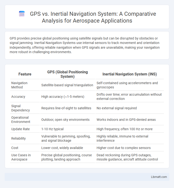
Table of Comparison
| Feature | GPS (Global Positioning System) | Inertial Navigation System (INS) |
|---|---|---|
| Navigation Method | Satellite-based signal triangulation | Self-contained using accelerometers and gyroscopes |
| Accuracy | High accuracy (~1-5 meters) | Drifts over time; error accumulation without external correction |
| Signal Dependency | Requires line-of-sight to satellites | No external signal required |
| Operational Environment | Outdoor, open sky environments | Works indoors and in GPS-denied areas |
| Update Rate | 1-10 Hz typical | High frequency, often 100 Hz or more |
| Reliability | Vulnerable to jamming, spoofing, and signal blockage | Highly reliable, immune to external interference |
| Cost | Lower cost, widely available | Higher cost due to complex sensors |
| Use Cases in Aerospace | Precise global positioning, course plotting, landing approach | Dead reckoning during GPS outages, missile guidance, aircraft attitude control |
Introduction to Navigation Technologies
GPS utilizes satellite signals to provide accurate, real-time geolocation data globally, making it essential for outdoor navigation and mapping. Inertial Navigation Systems (INS) rely on accelerometers and gyroscopes to calculate position, orientation, and velocity without external references, enabling autonomous navigation in GPS-denied environments. Combining GPS with INS enhances navigation precision and reliability across diverse applications such as aviation, maritime, and military operations.
What is GPS?
GPS (Global Positioning System) is a satellite-based navigation technology that provides precise location and time information anywhere on Earth by triangulating signals from a network of at least 24 satellites. It operates through a constellation of satellites orbiting the planet, enabling users to determine their latitude, longitude, and altitude with high accuracy. GPS is widely used in various applications such as transportation, mapping, and geolocation services due to its reliability and global coverage.
What is an Inertial Navigation System (INS)?
An Inertial Navigation System (INS) is a self-contained navigation technology that uses accelerometers and gyroscopes to continuously calculate position, velocity, and orientation without relying on external signals. Unlike GPS, which depends on satellite data, INS provides real-time navigation information by measuring the inertial forces acting on a moving object, making it highly effective in environments where GPS signals are weak or unavailable. INS is widely used in aerospace, maritime, and military applications for accurate dead-reckoning navigation.
Core Principles: How GPS Works
GPS operates by triangulating signals from a network of at least 24 satellites orbiting Earth, each transmitting precise time and location data. The receiver calculates its position by measuring the time delay of signals from multiple satellites, using trilateration to determine latitude, longitude, and altitude. This system relies on atomic clocks aboard satellites and requires a clear line of sight to multiple satellites for accurate positioning.
Core Principles: How Inertial Navigation Systems Work
Inertial Navigation Systems (INS) operate by continuously measuring acceleration and angular velocity using accelerometers and gyroscopes to calculate position, orientation, and velocity without relying on external signals. These systems integrate sensor data through algorithms like Strapdown INS or Mechanized INS to estimate movement relative to a known starting point. Unlike GPS, INS provides autonomous navigation capabilities, crucial for environments where satellite signals are obstructed or unavailable.
Accuracy Comparison: GPS vs INS
GPS provides global position accuracy ranging from 1 to 10 meters under open sky conditions, while Inertial Navigation Systems (INS) offer precise short-term measurements with errors accumulating over time due to sensor drift. INS excels in environments where GPS signals are blocked or degraded, maintaining continuous navigation data but requiring periodic GPS updates to correct long-term drift. Your choice depends on balancing GPS's broader accuracy with INS's reliability during signal interruptions.
Reliability and Signal Dependency
GPS relies heavily on satellite signals, making it vulnerable to signal loss in tunnels, dense urban areas, or under heavy foliage, which can compromise reliability. In contrast, Inertial Navigation Systems (INS) operate independently of external signals by using accelerometers and gyroscopes to calculate position, enhancing reliability in signal-deprived environments. Your navigation accuracy improves when combining GPS and INS, as the strengths of one system can compensate for the limitations of the other.
Use Cases and Applications
GPS excels in outdoor navigation for applications such as vehicle tracking, aviation, and maritime operations where satellite signals are reliable. Inertial Navigation Systems are essential in environments lacking GPS signals, including underwater navigation, aerospace missions, and military operations, providing accurate position data through motion sensors. Combining GPS with INS enhances navigation accuracy and reliability in complex scenarios like autonomous vehicles and aircraft flight control.
Cost and Maintenance Considerations
GPS systems generally incur lower initial costs but may require ongoing subscription fees and occasional hardware updates, while Inertial Navigation Systems (INS) typically have higher upfront expenses due to complex sensors and calibration needs but benefit from minimal external dependencies. Maintenance for GPS relies on satellite signal availability and receiver firmware updates, whereas INS demands regular sensor recalibration and can experience drift without corrective measures. Your choice should factor in long-term operational costs and the maintenance complexity specific to mission-critical navigation accuracy.
Future Trends in Navigation Technologies
Future trends in navigation technologies emphasize the integration of GPS and Inertial Navigation Systems (INS) to enhance accuracy and reliability in challenging environments. Advances in sensor miniaturization and machine learning algorithms enable more precise real-time positioning, even in GPS-denied areas such as underwater or urban canyons. Continuous improvements in multi-sensor fusion platforms are expected to drive the development of autonomous vehicles, drones, and robotics with robust navigation capabilities.
GPS vs Inertial Navigation System Infographic