Space-based sensors provide expansive, high-altitude coverage ideal for global monitoring and long-term environmental data collection, while airborne sensors offer higher resolution and flexibility for localized, detailed observations and rapid deployment. Your choice depends on the required scale, resolution, and mission duration of the sensing task.
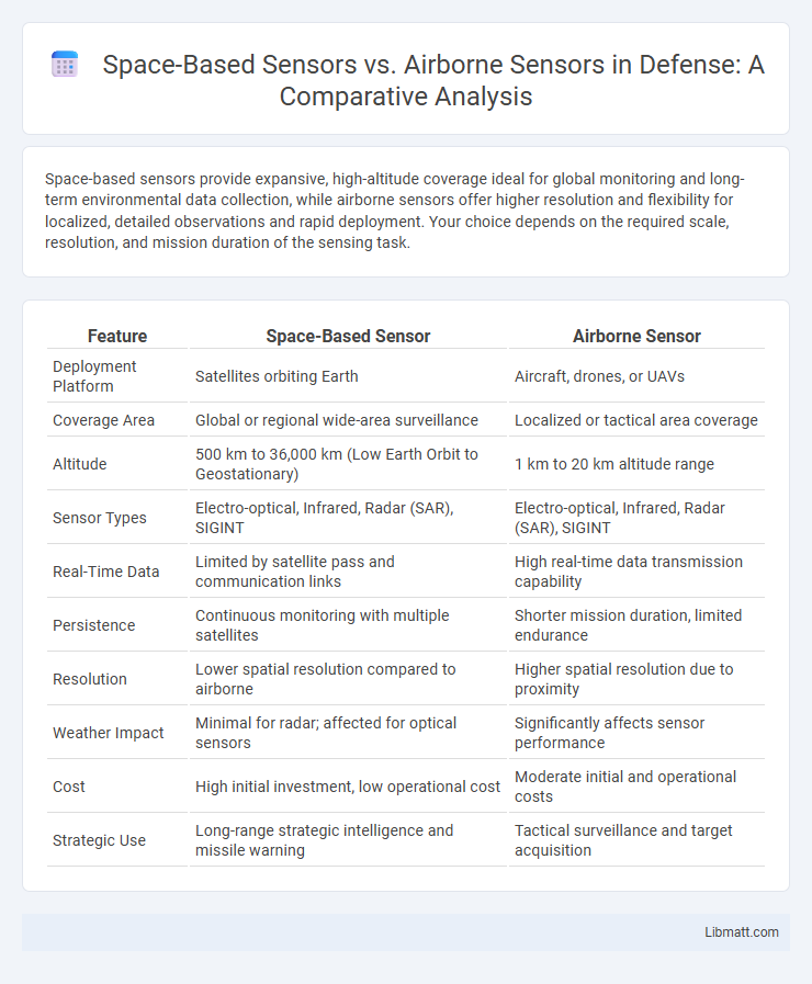
Table of Comparison
| Feature | Space-Based Sensor | Airborne Sensor |
|---|---|---|
| Deployment Platform | Satellites orbiting Earth | Aircraft, drones, or UAVs |
| Coverage Area | Global or regional wide-area surveillance | Localized or tactical area coverage |
| Altitude | 500 km to 36,000 km (Low Earth Orbit to Geostationary) | 1 km to 20 km altitude range |
| Sensor Types | Electro-optical, Infrared, Radar (SAR), SIGINT | Electro-optical, Infrared, Radar (SAR), SIGINT |
| Real-Time Data | Limited by satellite pass and communication links | High real-time data transmission capability |
| Persistence | Continuous monitoring with multiple satellites | Shorter mission duration, limited endurance |
| Resolution | Lower spatial resolution compared to airborne | Higher spatial resolution due to proximity |
| Weather Impact | Minimal for radar; affected for optical sensors | Significantly affects sensor performance |
| Cost | High initial investment, low operational cost | Moderate initial and operational costs |
| Strategic Use | Long-range strategic intelligence and missile warning | Tactical surveillance and target acquisition |
Introduction to Space-Based and Airborne Sensors
Space-based sensors orbit Earth, providing extensive, continuous monitoring of large geographic areas with high temporal resolution, ideal for climate studies, land use, and disaster management. Airborne sensors, mounted on aircraft or drones, offer higher spatial resolution and flexibility, allowing detailed data collection over targeted areas for environmental monitoring and precision agriculture. Both sensor types utilize multispectral and hyperspectral imaging technologies but differ fundamentally in coverage, resolution, and deployment costs.
Key Differences Between Space-Based and Airborne Sensors
Space-based sensors operate from satellites orbiting Earth, offering extensive geographic coverage and long-term monitoring capabilities, while airborne sensors are mounted on aircraft or drones, providing higher spatial resolution and flexibility for localized data collection. Space-based systems excel in wide-area environmental monitoring and climate studies due to their stable vantage point, whereas airborne sensors are preferred for detailed inspections, disaster assessment, and precision mapping. Understanding these distinctions helps you select the appropriate technology for your specific remote sensing needs.
Advantages of Space-Based Sensors
Space-based sensors provide continuous, large-scale environmental monitoring with global coverage unattainable by airborne sensors, enabling consistent data collection irrespective of weather or terrain. They offer superior spatial resolution and multispectral imaging capabilities essential for applications like climate monitoring and disaster management. These sensors facilitate long-term data acquisition for trend analysis, supporting critical decision-making in agriculture, urban planning, and national security.
Advantages of Airborne Sensors
Airborne sensors offer higher spatial resolution and flexibility in deployment altitude, enabling detailed and targeted data collection compared to space-based sensors. Your ability to position airborne platforms closer to the area of interest allows for rapid response and frequent revisits, enhancing real-time monitoring capabilities. These sensors are less affected by atmospheric interference, providing more accurate and reliable data for environmental and surveillance applications.
Limitations of Space-Based vs Airborne Sensors
Space-based sensors face limitations such as lower spatial resolution and delayed data acquisition due to fixed orbits, which can impede real-time monitoring and reduce image clarity. Airborne sensors provide higher resolution and more flexible deployment but are constrained by limited coverage area and higher operational costs. Understanding these trade-offs helps you select the optimal sensing platform for applications requiring timely, detailed environmental data.
Applications of Space-Based Sensors
Space-based sensors play a critical role in global environmental monitoring, providing real-time data on climate change, weather patterns, and natural disasters with extensive geographic coverage unattainable by airborne sensors. These sensors enable continuous observation of atmospheric conditions, oceanography, and land surface changes, supporting applications in meteorology, agriculture, and disaster response. Satellite platforms also facilitate large-scale surveillance for defense and security purposes, offering persistent and wide-area coverage beyond the reach of airborne sensor limitations.
Applications of Airborne Sensors
Airborne sensors are extensively utilized for environmental monitoring, precision agriculture, and disaster management due to their ability to capture high-resolution imagery and real-time data over specific target areas. These sensors support applications such as mapping vegetation health, assessing wildfire damage, and conducting mineral exploration with greater flexibility and lower operational costs compared to space-based sensors. Their proximity to the surface enhances spatial detail and temporal frequency, making them ideal for localized surveillance and rapid response initiatives.
Cost Comparison: Space-Based vs Airborne Sensors
Space-based sensors typically involve higher initial investment and operational costs due to satellite development, launch, and maintenance, whereas airborne sensors offer more flexible deployment with lower upfront expenses but higher per-mission costs. Your choice depends on the scale and frequency of data collection, as space-based options provide continuous, wide-area coverage while airborne sensors excel in targeted, mission-specific sensing. Long-term, space-based sensors may offer cost efficiency for large-scale monitoring, whereas airborne sensors suit short-term or localized applications.
Data Resolution and Coverage Analysis
Space-based sensors provide extensive coverage with the capability to capture data over vast geographic areas, making them ideal for monitoring large-scale phenomena, though their spatial resolution is generally lower compared to airborne sensors. Airborne sensors offer higher spatial resolution and finer detail, enabling precise data capture for localized studies and applications requiring close-range observation. Your choice between these sensors depends on the need for broad-area coverage versus detailed spatial resolution analytics.
Future Trends in Remote Sensing Technologies
Future trends in remote sensing technologies highlight advancements in space-based sensors offering global coverage, higher spatial resolution, and enhanced multispectral imaging capabilities, enabling more accurate environmental monitoring and disaster management. Airborne sensors are evolving with increased payload flexibility, real-time data processing, and integration with unmanned aerial vehicles (UAVs) to provide rapid, localized data collection and detailed terrain analysis. The convergence of artificial intelligence and machine learning algorithms with both platforms will drive improved data interpretation, predictive analytics, and autonomous sensor operations.
space-based sensor vs airborne sensor Infographic