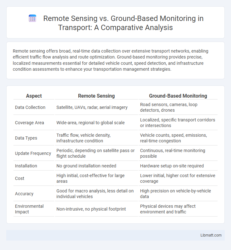
Remote sensing offers broad, real-time data collection over extensive transport networks, enabling efficient traffic flow analysis and route optimization. Ground-based monitoring provides precise, localized measurements essential for detailed vehicle count, speed detection, and infrastructure condition assessments to enhance your transportation management strategies.
Table of Comparison
| Aspect | Remote Sensing | Ground-Based Monitoring |
|---|---|---|
| Data Collection | Satellite, UAVs, radar, aerial imagery | Road sensors, cameras, loop detectors, drones |
| Coverage Area | Wide-area, regional to global scale | Localized, specific transport corridors or intersections |
| Data Types | Traffic flow, vehicle density, infrastructure condition | Vehicle counts, speed, emissions, real-time congestion |
| Update Frequency | Periodic, depending on satellite pass or flight schedule | Continuous, real-time monitoring possible |
| Installation | No ground installation needed | Hardware setup on-site required |
| Cost | High initial, cost-effective for large areas | Lower initial, higher cost for extensive coverage |
| Accuracy | Good for macro analysis, less detail on individual vehicles | High precision on vehicle-by-vehicle data |
| Environmental Impact | Non-intrusive, no physical footprint | Physical devices may affect environment and traffic |
Introduction to Transport Monitoring Techniques
Remote sensing in transport monitoring utilizes satellite imagery, aerial drones, and LiDAR technology to capture real-time traffic patterns, road conditions, and infrastructure changes over large areas with high temporal frequency. Ground-based monitoring relies on embedded sensors, cameras, loop detectors, and GPS devices installed on vehicles or along roadways to provide detailed, localized data on vehicle counts, speeds, and congestion levels. Combining both techniques enhances accuracy and coverage by integrating spatially extensive remote sensing data with high-resolution ground measurements for comprehensive transport system analysis.
Overview of Remote Sensing in Transport
Remote sensing in transport utilizes satellite imagery, aerial sensors, and drones to collect real-time data on traffic flow, road conditions, and infrastructure integrity without physical presence, enabling large-scale and continuous monitoring. These technologies facilitate the detection of congestion patterns, accident hotspots, and environmental impacts with high spatial and temporal resolution, supporting smarter traffic management systems. Compared to ground-based monitoring, remote sensing offers broader coverage and quicker data acquisition, though it may face limitations in data accuracy and weather dependency.
Ground-Based Monitoring: Methods and Applications
Ground-based monitoring in transport employs technologies such as radar sensors, inductive loops, and cameras to collect real-time traffic data, including vehicle count, speed, and classification. These methods enable precise detection of traffic flow, congestion patterns, and incident management at specific locations. Applications extend to traffic signal control, infrastructure maintenance planning, and safety assessments, enhancing overall transport system efficiency and reliability.
Data Accuracy: Remote Sensing vs Ground-Based Monitoring
Remote sensing offers broad spatial coverage and real-time data collection useful for tracking transportation patterns, but its accuracy may be affected by atmospheric conditions and sensor resolution. Ground-based monitoring provides high-precision, localized data crucial for detailed transport analysis and validation of remote sensing results. Your choice between these methods depends on the required data granularity and operational context in transport monitoring.
Spatial and Temporal Coverage Comparison
Remote sensing offers extensive spatial coverage, capturing large transport networks and urban areas from satellite or aerial platforms, enabling analysis across regions and countries. Ground-based monitoring provides highly detailed, localized data with precise temporal resolution, capturing real-time vehicle movements and traffic conditions on specific roads or intersections. Combining both methods enhances transport monitoring by balancing broad spatial insights from remote sensing with fine-grained temporal data from ground sensors.
Cost-Effectiveness and Resource Requirements
Remote sensing in transport monitoring offers significant cost-effectiveness by covering large geographic areas with minimal personnel and infrastructure investment compared to ground-based methods. Ground-based monitoring requires extensive on-site equipment, maintenance, and human resources, increasing operational costs and limiting scalability. Integrating remote sensing with selective ground-based validation maximizes resource efficiency while ensuring data accuracy.
Real-Time Monitoring Capabilities
Remote sensing technology in transport enables real-time monitoring over vast geographical areas using satellites and drones, offering continuous data collection without physical presence. Ground-based monitoring relies on fixed sensors, cameras, and IoT devices placed along transport routes, providing highly accurate and detailed local traffic and environmental data. Combining remote sensing with ground-based systems enhances real-time decision-making by integrating broad spatial coverage and precise localized insights.
Integration and Data Fusion Approaches
Integration and data fusion approaches combine remote sensing data from satellites, drones, and aerial vehicles with ground-based sensor inputs such as traffic cameras, GPS trackers, and inductive loops to enhance transport monitoring accuracy. Multisensor data fusion algorithms leverage spatial, temporal, and contextual information to provide real-time traffic flow analysis, incident detection, and infrastructure health assessment. This hybrid approach improves decision-making for urban mobility and intelligent transport systems by enabling comprehensive situational awareness and predictive analytics.
Use Cases: Urban Traffic and Highway Monitoring
Remote sensing offers large-scale urban traffic and highway monitoring by capturing real-time data on traffic flow, congestion patterns, and vehicle speed through satellite or aerial imagery. Ground-based monitoring uses sensors, cameras, and inductive loop detectors placed on roads for precise vehicle counts, lane-specific analysis, and incident detection. Combining remote sensing and ground-based methods enhances traffic management systems by providing comprehensive coverage and detailed, localized insights for optimizing your city's transportation infrastructure.
Future Trends in Transport Surveillance Technologies
Future trends in transport surveillance technologies emphasize the integration of remote sensing with ground-based monitoring to enhance real-time data accuracy and coverage. Advanced satellite imaging, drone-based sensors, and IoT-enabled ground sensors work synergistically to provide comprehensive traffic flow analysis, infrastructure health assessments, and incident detection. Your transport management can leverage these evolving technologies to improve safety, optimize routing, and reduce congestion through predictive analytics and automated decision-making systems.
remote sensing vs ground-based monitoring (transport) Infographic