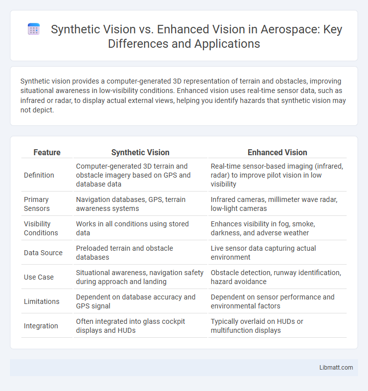
Synthetic vision provides a computer-generated 3D representation of terrain and obstacles, improving situational awareness in low-visibility conditions. Enhanced vision uses real-time sensor data, such as infrared or radar, to display actual external views, helping you identify hazards that synthetic vision may not depict.
Table of Comparison
| Feature | Synthetic Vision | Enhanced Vision |
|---|---|---|
| Definition | Computer-generated 3D terrain and obstacle imagery based on GPS and database data | Real-time sensor-based imaging (infrared, radar) to improve pilot vision in low visibility |
| Primary Sensors | Navigation databases, GPS, terrain awareness systems | Infrared cameras, millimeter wave radar, low-light cameras |
| Visibility Conditions | Works in all conditions using stored data | Enhances visibility in fog, smoke, darkness, and adverse weather |
| Data Source | Preloaded terrain and obstacle databases | Live sensor data capturing actual environment |
| Use Case | Situational awareness, navigation safety during approach and landing | Obstacle detection, runway identification, hazard avoidance |
| Limitations | Dependent on database accuracy and GPS signal | Dependent on sensor performance and environmental factors |
| Integration | Often integrated into glass cockpit displays and HUDs | Typically overlaid on HUDs or multifunction displays |
Introduction to Vision Systems in Aviation
Synthetic vision and enhanced vision systems are critical technologies in modern aviation that improve pilot situational awareness by providing clear, real-time imagery of the environment. Synthetic vision systems generate computer-based 3D terrain and obstacle representations from a database, unaffected by weather or visibility conditions, while enhanced vision systems use infrared or radar sensors to display live external views, improving pilot perception in low visibility conditions. Both systems integrate seamlessly with cockpit displays, contributing to safer navigation and approach procedures, especially in challenging environments.
Defining Synthetic Vision: Key Features and Functions
Synthetic vision integrates 3D terrain mapping, obstacle databases, and precise GPS data to create a real-time, computer-generated view of the environment, regardless of actual visibility conditions. Key features include terrain awareness, obstacle detection, and intuitive symbology that enhance pilot situational awareness by providing a clear virtual representation of the surroundings. Its functions support flight safety by reducing spatial disorientation and improving decision-making during low-visibility or night operations.
Understanding Enhanced Vision: Core Components
Enhanced vision integrates real-time sensor data, such as infrared and low-light cameras, to augment a pilot's natural view, improving situational awareness in adverse conditions. Core components include high-resolution displays, sensor fusion technology, and advanced processing units that combine multiple data sources to deliver a clear, comprehensive image of the environment. Understanding enhanced vision enables you to leverage these systems for safer navigation and obstacle avoidance during low-visibility operations.
Technology Behind Synthetic and Enhanced Vision
Synthetic vision utilizes advanced computer-generated 3D terrain databases and real-time GPS data to create a virtual representation of the environment, improving situational awareness in low-visibility conditions. Enhanced vision relies on infrared sensors and thermal imaging technology to provide pilots with a real-time visual overlay of actual terrain and obstacles through heads-up displays or cockpit screens. Both technologies integrate with avionics systems to enhance flight safety, but synthetic vision builds a predictive model while enhanced vision offers real-time thermal imaging feedback.
Comparing Display Interfaces and Usability
Synthetic vision systems generate computer-rendered 3D terrain and obstacle displays using GPS and onboard databases, enabling pilots to visualize the environment even in zero visibility conditions. Enhanced vision systems augment real-time infrared or low-light sensor imagery onto the cockpit display, providing actual external visuals that improve situational awareness in adverse weather. Display interfaces for synthetic vision emphasize predictive, terrain-focused visuals with intuitive symbology, while enhanced vision integrates live sensor data, offering a more realistic but sensor-dependent view, influencing usability depending on mission requirements and environmental conditions.
Operational Benefits: Safety and Situational Awareness
Synthetic vision systems (SVS) enhance operational safety by providing pilots with a clear, computer-generated 3D terrain display, allowing for improved situational awareness in low-visibility conditions and reducing the risk of controlled flight into terrain (CFIT). Enhanced vision systems (EVS) use infrared or other sensor technologies to display real-time external imagery, offering pilots the ability to detect obstacles, runway features, and other aircraft beyond visual line-of-sight, especially in adverse weather conditions. Both technologies significantly improve situational awareness, but SVS excels in preemptive terrain awareness while EVS provides real-time obstacle detection, collectively enhancing overall flight safety.
Limitations and Challenges of Both Systems
Synthetic vision systems face limitations such as data dependency, requiring accurate, up-to-date terrain and obstacle databases, which can lead to errors in unfamiliar or rapidly changing environments. Enhanced vision systems contend with challenges like sensor performance degradation under adverse weather conditions, including fog, rain, and glare, reducing image clarity and pilot situational awareness. Both technologies must overcome issues related to system integration, latency, and reliance on external inputs to ensure reliable and comprehensive pilot visibility in complex flight scenarios.
Regulatory Standards and Certification
Synthetic vision systems (SVS) and enhanced vision systems (EVS) are subject to strict regulatory standards and certification processes governed by aviation authorities such as the FAA and EASA. SVS, relying on terrain databases and sensor fusion, must demonstrate high accuracy and reliability in rendering synthetic imagery, adhering to RTCA DO-315 and EUROCAE ED-179 guidelines. EVS, utilizing real-time sensor inputs like infrared or radar, requires certification that ensures its sensor performance and integration meet standards for operational safety and pilot situational awareness enhancements under DO-340/ED-183 frameworks.
Integration into Modern Cockpits
Synthetic vision systems (SVS) provide pilots with a computer-generated 3D terrain map using GPS and onboard databases, enhancing situational awareness in all visibility conditions. Enhanced vision systems (EVS) utilize infrared or other sensor technologies to display real-time external views on cockpit displays, improving pilot perception during low-visibility operations. Modern cockpits integrate both SVS and EVS to deliver seamless, augmented reality experiences that improve safety, reduce pilot workload, and support precision navigation.
Future Trends in Vision Technologies for Aviation
Synthetic vision systems (SVS) generate real-time, computer-rendered 3D terrain models using GPS and terrain databases to improve pilot situational awareness in all weather conditions. Enhanced vision systems (EVS) utilize infrared and other sensor technologies to provide real-time imagery of the external environment, penetrating fog, rain, and darkness to reveal obstacles and terrain. Future trends in aviation vision technologies emphasize integrating SVS and EVS with augmented reality overlays, improved sensor fusion, and AI-assisted hazard detection to create comprehensive, intuitive pilot displays that enhance safety and operational efficiency.
Synthetic vision vs Enhanced vision Infographic