NAVTEX provides essential navigational and meteorological warnings via radio broadcasts, ensuring real-time safety information at sea, while ECDIS offers an interactive electronic chart system that integrates various navigational data for precise route planning and monitoring. Your maritime navigation becomes significantly safer and more efficient by combining NAVTEX updates with the comprehensive display capabilities of ECDIS.
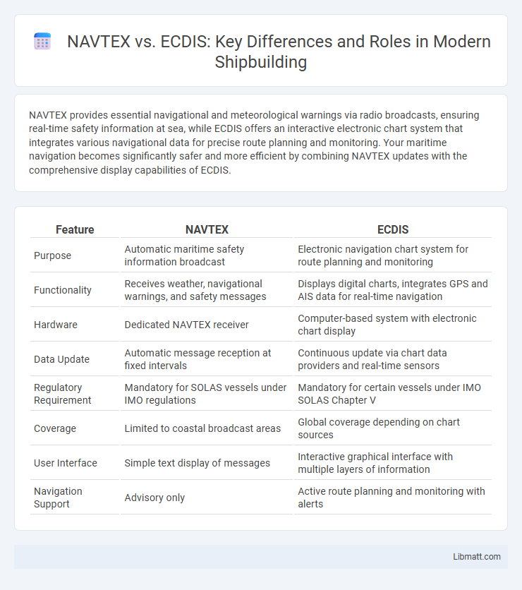
Table of Comparison
| Feature | NAVTEX | ECDIS |
|---|---|---|
| Purpose | Automatic maritime safety information broadcast | Electronic navigation chart system for route planning and monitoring |
| Functionality | Receives weather, navigational warnings, and safety messages | Displays digital charts, integrates GPS and AIS data for real-time navigation |
| Hardware | Dedicated NAVTEX receiver | Computer-based system with electronic chart display |
| Data Update | Automatic message reception at fixed intervals | Continuous update via chart data providers and real-time sensors |
| Regulatory Requirement | Mandatory for SOLAS vessels under IMO regulations | Mandatory for certain vessels under IMO SOLAS Chapter V |
| Coverage | Limited to coastal broadcast areas | Global coverage depending on chart sources |
| User Interface | Simple text display of messages | Interactive graphical interface with multiple layers of information |
| Navigation Support | Advisory only | Active route planning and monitoring with alerts |
Introduction to NAVTEX and ECDIS
NAVTEX (Navigational Telex) is an automated maritime communication system that broadcasts navigational and meteorological warnings directly to ships within coastal areas. ECDIS (Electronic Chart Display and Information System) is an advanced digital navigation system that integrates electronic charts with real-time positional data to support safe and efficient voyage planning and monitoring. Both systems play critical roles in maritime safety, with NAVTEX providing essential navigational warnings and ECDIS offering dynamic, interactive chart displays for route management.
Purpose and Functionality of NAVTEX
NAVTEX serves as an automated medium for broadcasting navigational and meteorological warnings directly to ships, ensuring they receive crucial safety information without manual intervention. This system transmits text-based messages, such as weather forecasts, search and rescue notifications, and navigational warnings, enhancing maritime situational awareness. While ECDIS provides comprehensive electronic charting and route planning, NAVTEX's primary purpose is delivering timely, standardized safety messages to support Your vessel's safe navigation.
Core Features of ECDIS
ECDIS (Electronic Chart Display and Information System) offers crucial features such as real-time positioning using GPS, integrated electronic nautical charts, and automatic route planning and monitoring to enhance maritime navigation safety. Its advanced alarm systems and continuous voyage data recording provide situational awareness beyond the capabilities of NAVTEX, which primarily delivers navigational warnings and weather updates via radio transmissions. ECDIS supports compliance with SOLAS regulations through detailed chart management and interaction with other onboard sensors, making it indispensable for modern ship navigation.
Data Transmission and Presentation
NAVTEX transmits navigational and meteorological warnings using radio broadcasts on specific frequencies, delivering text-based messages directly to compatible receivers onboard ships. ECDIS integrates data from multiple sources such as GPS, radar, and AIS, displaying real-time electronic navigational charts for comprehensive situational awareness. NAVTEX provides basic, periodic message updates, while ECDIS offers continuous, dynamic visual presentation essential for route planning and hazard avoidance.
Navigational Benefits: NAVTEX vs ECDIS
NAVTEX provides real-time maritime safety information and navigational warnings through automated text messages, essential for enhancing your situational awareness during voyages. ECDIS integrates electronic nautical charts with onboard sensors for precise route planning and dynamic hazard detection, minimizing human error and improving voyage efficiency. Combining NAVTEX with ECDIS ensures comprehensive navigational benefits by delivering timely updates and advanced chart management for safer maritime operations.
Integration with Other Maritime Systems
NAVTEX systems provide essential navigational warnings and weather updates by receiving and displaying maritime safety information but operate primarily as standalone devices with limited integration capabilities. ECDIS integrates seamlessly with GPS, radar, AIS, and other bridge systems, enabling comprehensive situational awareness and enhancing navigational decision-making. Advanced ECDIS platforms support data sharing and real-time synchronization, optimizing route planning and safety management across multiple maritime systems.
Regulatory Requirements and Compliance
NAVTEX operates under International Maritime Organization (IMO) regulations as part of the Global Maritime Distress and Safety System (GMDSS), making it mandatory for vessels to receive navigational warnings and weather forecasts. ECDIS compliance is governed by the IMO's SOLAS Chapter V, requiring ships to carry type-approved electronic charts and maintain up-to-date navigational data to meet safety standards. Your vessel must comply with both systems to ensure adherence to international maritime safety and navigation regulations.
User Interface and Operational Ease
NAVTEX features a simple, text-based interface designed for straightforward reception of maritime safety information, allowing quick access to critical navigational warnings without complex controls. ECDIS offers a graphical, interactive display integrating multiple data sources like charts and real-time vessel positioning, enhancing situational awareness through detailed visualizations and customizable layers. While NAVTEX is operationally easy for receiving alerts, ECDIS provides advanced operational functionality with a steeper learning curve but greater efficiency for route planning and hazard avoidance.
Limitations and Challenges
NAVTEX faces limitations in range and message capacity, restricting the volume and timeliness of navigational warnings it can provide. ECDIS relies heavily on the accuracy and currency of electronic charts, making it vulnerable to outdated or incorrect data that can compromise navigational safety. Your maritime operations benefit most when these systems are used complementarily, addressing their individual challenges for reliable situational awareness.
Choosing Between NAVTEX and ECDIS
Choosing between NAVTEX and ECDIS depends on your vessel's navigational needs and operational environment. NAVTEX provides essential maritime safety information through automated radio broadcasts, making it a reliable backup for receiving weather warnings and navigational warnings. ECDIS offers comprehensive digital charting with real-time positioning, enhancing your situational awareness and route planning capabilities, ideal for modern, integrated navigation systems.
NAVTEX vs ECDIS Infographic