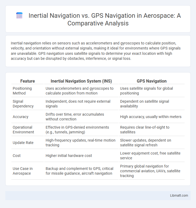
Inertial navigation relies on sensors such as accelerometers and gyroscopes to calculate position, velocity, and orientation without external signals, making it ideal for environments where GPS signals are unavailable. GPS navigation uses satellite signals to determine your exact location with high accuracy but can be disrupted by obstacles, interference, or signal loss.
Table of Comparison
| Feature | Inertial Navigation System (INS) | GPS Navigation |
|---|---|---|
| Positioning Method | Uses accelerometers and gyroscopes to calculate position from motion | Uses satellite signals for global positioning |
| Signal Dependency | Independent, does not require external signals | Dependent on satellite signal availability |
| Accuracy | Drifts over time, error accumulates without correction | High accuracy, usually within meters |
| Operational Environment | Effective in GPS-denied environments (e.g., tunnels, jamming) | Requires clear line-of-sight to satellites |
| Update Rate | High-frequency updates, real-time motion tracking | Slower updates, dependent on satellite signal refresh |
| Cost | Higher initial hardware cost | Lower equipment cost, free satellite service |
| Use Case in Aerospace | Backup and complement to GPS, critical for missile guidance, aircraft navigation | Primary global navigation for commercial aviation, UAVs, satellite tracking |
Introduction to Inertial and GPS Navigation
Inertial navigation systems (INS) utilize accelerometers and gyroscopes to calculate position, orientation, and velocity without external references, enabling precise navigation in GPS-denied environments. GPS navigation relies on satellite signals to provide accurate global positioning and timing information based on trilateration from multiple satellites. Combining INS with GPS enhances navigation accuracy and reliability, especially in dynamic or obstructed conditions.
Basic Principles of Inertial Navigation
Inertial navigation relies on sensors such as accelerometers and gyroscopes to track position, velocity, and orientation by measuring the acceleration and angular velocity from a known starting point. Unlike GPS navigation, which depends on satellite signals, this system calculates movement internally, allowing continuous tracking even in environments without external signals. Your navigation accuracy depends on sensor precision and drift correction, making inertial navigation ideal for applications requiring autonomy and signal independence.
Fundamentals of GPS Navigation Systems
GPS navigation systems rely on a constellation of at least 24 satellites orbiting Earth, transmitting signals that allow receivers to calculate precise geographic positions through trilateration. The core components include space, control, and user segments, where atomic clocks on satellites provide time-stamped data essential for determining distance by measuring signal travel time. GPS navigation offers global coverage and high accuracy but is vulnerable to signal blockages and interference, unlike inertial navigation systems that operate independently using internal sensors.
Key Differences Between Inertial and GPS Navigation
Inertial navigation relies on accelerometers and gyroscopes to track position, velocity, and orientation without external signals, enabling use in GPS-denied environments. GPS navigation uses satellite signals to provide precise global positioning, but can suffer from signal loss or jamming. The key difference lies in inertial navigation's self-contained system offering continuous data, while GPS depends on external satellite connectivity for absolute positioning.
Advantages of Inertial Navigation Systems
Inertial Navigation Systems (INS) provide continuous positioning without reliance on external signals, maintaining accuracy in GPS-denied environments such as underwater, tunnels, or remote areas. INS offers high update rates and short-term precision, crucial for applications like aircraft, submarines, and autonomous vehicles where immediate and reliable data is essential. Your navigation capabilities benefit significantly from the system's robustness against jamming and signal disruption, ensuring consistent performance in challenging conditions.
Strengths of GPS Navigation Technology
GPS navigation technology provides highly accurate positioning and real-time location data by utilizing a global network of satellites. Its strengths include wide coverage, reliable signal availability outdoors, and the ability to support various applications such as mapping, tracking, and turn-by-turn directions. You benefit from continuous updates and precise navigation even in remote areas where other systems may struggle.
Limitations and Challenges of Inertial Navigation
Inertial navigation systems (INS) face limitations such as sensor drift and cumulative errors over time, which degrade positional accuracy without periodic external updates. Unlike GPS navigation, INS cannot correct these errors independently, making long-term accuracy a challenge in environments with signal interruptions or GPS denial. Your reliance on inertial navigation alone may result in position inaccuracies, especially during extended operations or high-dynamic scenarios.
Drawbacks and Limitations of GPS Navigation
GPS navigation relies heavily on satellite signals, which can be obstructed by tall buildings, dense forests, or tunnels, leading to signal loss and inaccurate positioning. It is susceptible to interference from atmospheric conditions, signal jamming, and deliberate spoofing, posing security and reliability concerns. Your navigation system may fail in remote or hostile environments where GPS coverage is weak or unavailable, limiting its effectiveness for critical applications.
Hybrid and Integrated Navigation Solutions
Hybrid and integrated navigation solutions combine inertial navigation systems (INS) with GPS to enhance accuracy and reliability, especially in environments where GPS signals are weak or unavailable. These systems utilize INS to provide continuous position updates during GPS outages, while GPS corrects the drift errors inherent in inertial sensors. The fusion of data from both sources through algorithms like Kalman filtering ensures robust navigation performance for aerospace, automotive, and maritime applications.
Choosing the Right Navigation System for Your Application
Inertial navigation systems provide continuous position data without relying on external signals, making them ideal for environments where GPS signals are unavailable or jammed, such as underwater or inside buildings. GPS navigation systems offer high accuracy and global coverage by utilizing satellite signals, best suited for outdoor applications with clear line-of-sight to satellites. Selecting the right navigation system depends on factors such as operational environment, required position accuracy, signal availability, and susceptibility to interference.
inertial navigation vs GPS navigation Infographic