LIDAR uses laser light to create highly detailed, high-resolution maps ideal for precise distance measurement and object detection in autonomous vehicles. RADAR relies on radio waves, offering better performance in poor weather conditions and longer detection ranges, making it suitable for tracking larger objects and speed measurement.
Table of Comparison
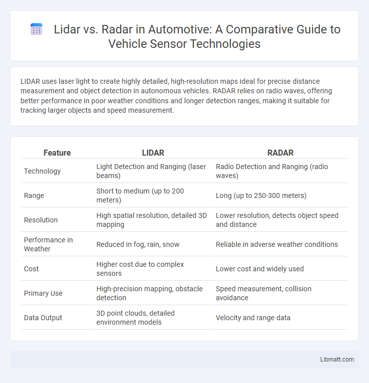
| Feature | LIDAR | RADAR |
|---|---|---|
| Technology | Light Detection and Ranging (laser beams) | Radio Detection and Ranging (radio waves) |
| Range | Short to medium (up to 200 meters) | Long (up to 250-300 meters) |
| Resolution | High spatial resolution, detailed 3D mapping | Lower resolution, detects object speed and distance |
| Performance in Weather | Reduced in fog, rain, snow | Reliable in adverse weather conditions |
| Cost | Higher cost due to complex sensors | Lower cost and widely used |
| Primary Use | High-precision mapping, obstacle detection | Speed measurement, collision avoidance |
| Data Output | 3D point clouds, detailed environment models | Velocity and range data |
Introduction to LIDAR and RADAR
LIDAR (Light Detection and Ranging) and RADAR (Radio Detection and Ranging) are advanced sensing technologies used for detecting objects and measuring distances. LIDAR uses laser light pulses to create high-resolution, 3D maps of environments, making it ideal for applications like autonomous vehicles and topographic mapping. RADAR relies on radio waves to detect object speed and range, providing robust performance in various weather conditions and long-distance detection scenarios suitable for aviation and maritime navigation.
How LIDAR Works
LIDAR operates by emitting laser pulses that bounce off objects and return to the sensor, creating a detailed 3D map of the environment. The time it takes for the light to return is measured precisely, allowing for accurate distance calculations and object detection. Your autonomous vehicle or mapping system relies on this high-resolution data to navigate and analyze surroundings with greater detail than RADAR.
How RADAR Works
RADAR operates by emitting radio waves that reflect off objects and return to the sensor, allowing for the calculation of distance, speed, and direction based on the time delay and frequency shift of the returned signals. It functions effectively in various weather conditions, such as fog, rain, and dust, due to the longer wavelengths of radio waves that penetrate obstacles better than light waves. RADAR systems are widely used in automotive safety, aviation, and maritime navigation for real-time object detection and tracking.
Key Differences Between LIDAR and RADAR
LIDAR uses laser pulses to create high-resolution 3D maps by measuring the time it takes for light to return, offering precise distance and shape detection ideal for autonomous vehicles and topographical mapping. RADAR emits radio waves to detect objects and measure their speed and distance, excelling in adverse weather conditions and long-range detection for applications like aviation and maritime navigation. LIDAR provides finer spatial resolution, while RADAR's superior penetration through fog, rain, and dust highlights their complementary roles in object detection and environmental sensing.
Accuracy and Resolution Comparison
LIDAR offers higher accuracy and finer resolution than RADAR, capable of producing detailed 3D maps with centimeter-level precision. RADAR provides robust detection over longer distances and in adverse weather but with lower spatial resolution, typically measured in meters. Your choice depends on the application's need for detailed environmental mapping versus long-range object detection.
Weather and Environmental Performance
LIDAR systems experience reduced accuracy in adverse weather conditions such as fog, rain, and snow due to light scattering, which diminishes signal reliability. RADAR technology excels in harsh environments by using radio waves that penetrate fog, rain, and dust, maintaining consistent performance and longer detection ranges. Consequently, RADAR is preferred for reliable object detection in challenging weather, while LIDAR provides higher resolution in clear conditions.
Cost and Accessibility Factors
LIDAR systems typically have higher costs due to expensive components like lasers and photodetectors, limiting accessibility for widespread consumer use. RADAR technology is generally more affordable and accessible because it uses mature, mass-produced radio frequency components. Your choice between LIDAR and RADAR should consider budget constraints and the availability of sensors suited for specific applications.
Applications in Autonomous Vehicles
LIDAR provides high-resolution 3D mapping essential for precise object detection and terrain modeling in autonomous vehicles, enabling accurate navigation and obstacle avoidance. RADAR excels in long-range detection and performs reliably under adverse weather conditions like fog, rain, and snow, offering critical support for adaptive cruise control and collision warning systems. Combining LIDAR's spatial accuracy with RADAR's robust sensing capabilities enhances overall vehicle perception and safety in autonomous driving.
Safety and Reliability Considerations
LIDAR offers high-resolution, precise distance measurements essential for accurate object detection in autonomous vehicles, but can be affected by weather conditions such as fog, rain, and dust, which may reduce reliability. RADAR provides robust performance in various weather scenarios with longer detection ranges, contributing to safer vehicle operation under adverse environmental conditions, though with lower spatial resolution than LIDAR. Combining LIDAR and RADAR systems enhances overall safety and reliability by leveraging the strengths of both technologies for comprehensive environmental sensing.
Future Trends and Innovations
LIDAR and RADAR technologies are rapidly evolving, with future trends focusing on enhanced resolution, improved signal processing, and integration with AI for autonomous systems. LIDAR innovations aim to reduce cost and size while increasing detection range and accuracy, enabling widespread adoption in automotive and mapping industries. RADAR advancements prioritize higher frequency bands and sensor fusion techniques to improve object recognition and environmental awareness, ensuring Your autonomous vehicles navigate safely in complex scenarios.
LIDAR vs RADAR Infographic