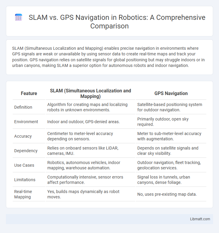
SLAM (Simultaneous Localization and Mapping) enables precise navigation in environments where GPS signals are weak or unavailable by using sensor data to create real-time maps and track your position. GPS navigation relies on satellite signals for global positioning but may struggle indoors or in urban canyons, making SLAM a superior option for autonomous robots and indoor navigation.
Table of Comparison
| Feature | SLAM (Simultaneous Localization and Mapping) | GPS Navigation |
|---|---|---|
| Definition | Algorithm for creating maps and localizing robots in unknown environments. | Satellite-based positioning system for outdoor navigation. |
| Environment | Indoor and outdoor, GPS-denied areas. | Primarily outdoor, open sky required. |
| Accuracy | Centimeter to meter-level accuracy depending on sensors. | Meter to sub-meter-level accuracy with augmentation. |
| Dependency | Relies on onboard sensors like LiDAR, cameras, IMU. | Depends on satellite signals and clear sky visibility. |
| Use Cases | Robotics, autonomous vehicles, indoor mapping, warehouse automation. | Outdoor navigation, fleet tracking, geolocation services. |
| Limitations | Computationally intensive, sensor errors affect performance. | Signal loss in tunnels, urban canyons, dense foliage. |
| Real-time Mapping | Yes, builds maps dynamically as robot moves. | No, uses pre-existing map data. |
Introduction to SLAM and GPS Navigation
SLAM (Simultaneous Localization and Mapping) is a technology that enables a device to build a map of an unknown environment while simultaneously tracking its location within that space. GPS navigation relies on satellite signals to determine precise geographic positioning globally but struggles indoors or in areas with obstructed views of the sky. Your choice between SLAM and GPS navigation depends on whether you require accurate indoor mapping or outdoor positional accuracy.
How SLAM Works: An Overview
SLAM (Simultaneous Localization and Mapping) works by using sensors such as LIDAR, cameras, or radar to continuously scan the environment while building a map and determining the device's position in real time. Unlike GPS, which relies on satellite signals for location, SLAM processes sensor data to create a spatial map and track movement indoors or in GPS-denied environments. Your navigation system benefits from SLAM's ability to provide accurate, detailed positioning where GPS signals are weak or unavailable.
Understanding GPS Navigation Systems
GPS navigation systems rely on satellite signals to provide accurate location data by triangulating positions based on signals from multiple satellites in real-time. These systems are widely used in outdoor environments where unobstructed satellite signals ensure precise tracking and routing. However, GPS accuracy can degrade in urban canyons, dense forests, or indoor settings, where signal blockage or multipath errors occur, necessitating alternative or complementary technologies for reliable navigation.
Key Differences Between SLAM and GPS
SLAM (Simultaneous Localization and Mapping) uses real-time sensor data such as LiDAR, cameras, and IMUs to build and update maps while determining the device's position within unknown environments. GPS Navigation relies on satellite signals to provide absolute geographic coordinates but struggles in indoor or obstructed areas where signal reception is poor. SLAM excels in dynamic, GPS-denied settings by constructing detailed local maps, whereas GPS offers broad, global positioning with limited precision in complex or indoor scenarios.
Accuracy and Reliability Comparison
Simultaneous Localization and Mapping (SLAM) offers superior accuracy in indoor environments where GPS signals are weak or unavailable, providing precise real-time mapping and localization. GPS navigation excels in outdoor settings with unobstructed satellite visibility, delivering reliable global positioning but suffers from signal degradation in urban canyons or dense foliage. Combining SLAM with GPS can enhance overall navigation reliability by leveraging SLAM's detailed local mapping alongside GPS's broad area coverage.
Application Areas: SLAM vs GPS
SLAM (Simultaneous Localization and Mapping) excels in indoor and GPS-denied environments such as robotics, augmented reality, and autonomous drones, enabling precise real-time mapping and navigation where GPS signals are unavailable or unreliable. GPS navigation dominates outdoor applications like vehicle routing, aviation, and maritime navigation, providing global positioning with broad coverage but limited accuracy indoors or in obstructed areas. Your choice between SLAM and GPS depends on the operational setting, as SLAM is ideal for confined or complex spaces while GPS suits large-scale outdoor navigation.
Strengths and Limitations of SLAM
SLAM (Simultaneous Localization and Mapping) excels in environments where GPS signals are weak or unavailable, such as indoors or urban canyons, by creating real-time maps while tracking the device's position. Its strengths include high accuracy in complex, dynamic settings and the ability to operate without external infrastructure. Limitations involve high computational demands, sensitivity to sensor noise, and challenges in large-scale or feature-poor environments where map consistency degrades.
Pros and Cons of GPS Navigation
GPS navigation offers global coverage with real-time location tracking, making it highly effective for outdoor navigation across vast areas. However, it struggles with signal loss or inaccuracies in urban canyons, dense forests, or indoor environments due to satellite visibility limitations. Dependency on satellite signals also introduces vulnerabilities such as susceptibility to jamming, interference, and lower performance in GPS-denied areas.
Future Trends in Navigation Technologies
Future navigation technologies increasingly integrate SLAM (Simultaneous Localization and Mapping) with GPS to enhance accuracy and reliability in complex environments. Advances in AI-driven SLAM algorithms enable real-time 3D mapping and obstacle detection, overcoming GPS limitations in urban canyons or indoor spaces. Your navigation experience will benefit from hybrid systems combining satellite data with sensor fusion, ensuring seamless positioning accuracy across diverse applications.
Choosing the Right Navigation System
Selecting the right navigation system depends on the environment and application requirements: SLAM (Simultaneous Localization and Mapping) excels in indoor or GPS-denied areas by creating real-time maps and localizing the user through sensor data fusion, while GPS navigation provides reliable positioning outdoors with global satellite signals. SLAM systems use sensors like LIDAR, cameras, and IMUs to continuously update maps, enabling precise navigation in complex environments such as warehouses and urban canyons where GPS signals may falter. For outdoor, large-scale, or open-area navigation, GPS remains the preferred choice due to its broad coverage and consistent accuracy under clear sky conditions.
SLAM vs GPS Navigation Infographic