Cartesian coordinates describe a point in space using perpendicular axes (x and y), making them ideal for grid-based systems and straightforward distance calculations. Polar coordinates represent points by a distance from the origin and an angle, which simplifies problems involving circular or rotational symmetry and is useful in fields such as physics and engineering.
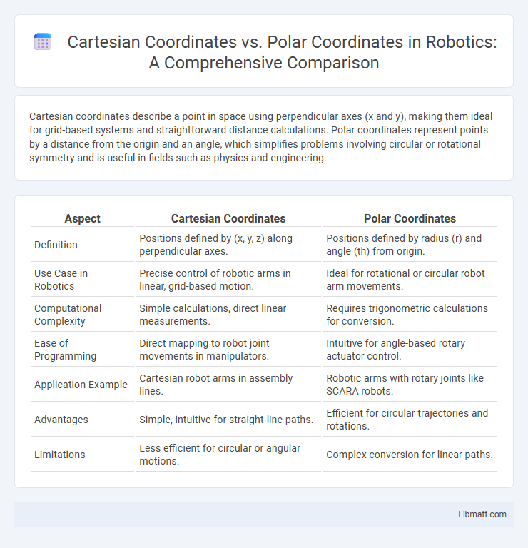
Table of Comparison
| Aspect | Cartesian Coordinates | Polar Coordinates |
|---|---|---|
| Definition | Positions defined by (x, y, z) along perpendicular axes. | Positions defined by radius (r) and angle (th) from origin. |
| Use Case in Robotics | Precise control of robotic arms in linear, grid-based motion. | Ideal for rotational or circular robot arm movements. |
| Computational Complexity | Simple calculations, direct linear measurements. | Requires trigonometric calculations for conversion. |
| Ease of Programming | Direct mapping to robot joint movements in manipulators. | Intuitive for angle-based rotary actuator control. |
| Application Example | Cartesian robot arms in assembly lines. | Robotic arms with rotary joints like SCARA robots. |
| Advantages | Simple, intuitive for straight-line paths. | Efficient for circular trajectories and rotations. |
| Limitations | Less efficient for circular or angular motions. | Complex conversion for linear paths. |
Introduction to Coordinate Systems
Cartesian coordinates represent points using perpendicular axes defined by x and y values, ideal for grid-based navigation and rectangular geometry. Polar coordinates express points based on a distance from a fixed origin and an angle from a reference direction, simplifying calculations involving rotations and circular shapes. Each system offers unique advantages for representing spatial data, with Cartesian suited for linear layouts and Polar preferred in contexts involving radial symmetry.
What Are Cartesian Coordinates?
Cartesian coordinates define a system where each point in a plane is represented by an ordered pair (x, y), indicating its horizontal and vertical distances from a fixed origin. This coordinate system uses perpendicular axes, typically labeled x-axis and y-axis, to measure linear displacement. It is fundamental in algebra, geometry, and many applications involving spatial relationships and analytic geometry.
What Are Polar Coordinates?
Polar coordinates represent a point in a plane using a distance from a reference point called the origin and an angle from a fixed direction, typically the positive x-axis. Unlike Cartesian coordinates that use horizontal (x) and vertical (y) distances, polar coordinates use radius (r) and angle (th) to describe positions. You can convert between these systems for tasks involving circular or rotational symmetry, making polar coordinates essential in fields like physics and engineering.
Mathematical Definitions and Notations
Cartesian coordinates represent points using an ordered pair (x, y) corresponding to horizontal and vertical distances from the origin on a 2D plane. Polar coordinates define points by a radius r and an angle th, indicating the distance from the origin and direction relative to the positive x-axis. Your choice depends on whether you prefer linear measurements or angular relationships for solving geometric and trigonometric problems.
Plotting Points: Cartesian vs Polar
Plotting points in Cartesian coordinates involves specifying exact horizontal (x) and vertical (y) distances from the origin, making it ideal for grid-based mapping and rectangular shapes. In contrast, Polar coordinates define points by their distance (r) from the origin and the angle (th) relative to the positive x-axis, which simplifies representing circular and rotational symmetry. This distinction makes Cartesian systems preferred for linear plotting and Polar coordinates better suited for scenarios involving curves and radial patterns.
Converting Between Cartesian and Polar
Converting between Cartesian coordinates \((x, y)\) and polar coordinates \((r, \theta)\) involves using the formulas \(r = \sqrt{x^2 + y^2}\) and \(\theta = \tan^{-1}(y/x)\) to transform Cartesian points into polar form. To convert back, polar coordinates are expressed as \(x = r \cos \theta\) and \(y = r \sin \theta\), facilitating seamless transitions between the two systems for applications in mathematics, physics, and engineering. Accurate angle measurement and quadrant consideration are critical for precise coordinate conversion, especially when dealing with negative values of \(x\) or \(y\).
Applications in Mathematics and Engineering
Cartesian coordinates are widely used in engineering for designing structures, electrical circuits, and robotics due to their straightforward representation of points via perpendicular x and y axes. Polar coordinates are essential in mathematics and engineering for analyzing rotational systems, wave functions, and electromagnetic fields, where angles and radii simplify complex problems. Both coordinate systems enable accurate modeling, simulation, and problem-solving in fields such as mechanical engineering, computer graphics, and physics.
Advantages and Disadvantages of Each System
Cartesian coordinates offer straightforward representation and manipulation of points using perpendicular x and y axes, facilitating easier calculation in geometry and algebraic equations. Polar coordinates provide a natural approach for problems involving circular or rotational symmetry by expressing points with a radius and angle, simplifying equations of curves like spirals and circles. Cartesian systems may become complex for circular motions, while polar coordinates can complicate linear translations and require trigonometric functions for conversions.
Common Mistakes and Misconceptions
Common mistakes in Cartesian vs. Polar coordinates include confusing the radius with the x-coordinate or misinterpreting the angle in Polar coordinates as linear distance, leading to errors in plotting points. People often overlook that the angle in Polar coordinates is measured from the positive x-axis counterclockwise, causing incorrect placement on the plane. Understanding these distinctions helps you avoid misrepresenting points and ensures accurate coordinate conversions between Cartesian and Polar systems.
Conclusion and Key Takeaways
Cartesian coordinates use perpendicular axes (x, y) to define points by horizontal and vertical distances, ideal for grid-based layouts and straightforward algebraic calculations. Polar coordinates represent points by a radius and angle (r, th), excelling in circular or rotational contexts and simplifying equations involving curves or periodic functions. Choosing between these systems depends on the problem geometry and computational convenience, with Cartesian favored for linear problems and Polar preferred for radial symmetry.
Cartesian coordinates vs Polar coordinates Infographic