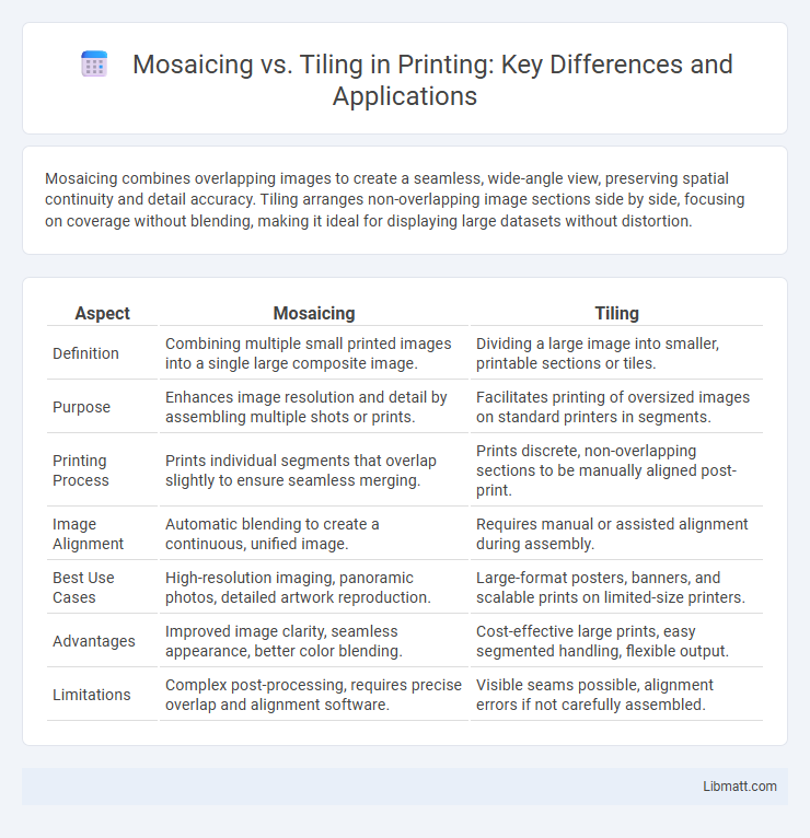
Mosaicing combines overlapping images to create a seamless, wide-angle view, preserving spatial continuity and detail accuracy. Tiling arranges non-overlapping image sections side by side, focusing on coverage without blending, making it ideal for displaying large datasets without distortion.
Table of Comparison
| Aspect | Mosaicing | Tiling |
|---|---|---|
| Definition | Combining multiple small printed images into a single large composite image. | Dividing a large image into smaller, printable sections or tiles. |
| Purpose | Enhances image resolution and detail by assembling multiple shots or prints. | Facilitates printing of oversized images on standard printers in segments. |
| Printing Process | Prints individual segments that overlap slightly to ensure seamless merging. | Prints discrete, non-overlapping sections to be manually aligned post-print. |
| Image Alignment | Automatic blending to create a continuous, unified image. | Requires manual or assisted alignment during assembly. |
| Best Use Cases | High-resolution imaging, panoramic photos, detailed artwork reproduction. | Large-format posters, banners, and scalable prints on limited-size printers. |
| Advantages | Improved image clarity, seamless appearance, better color blending. | Cost-effective large prints, easy segmented handling, flexible output. |
| Limitations | Complex post-processing, requires precise overlap and alignment software. | Visible seams possible, alignment errors if not carefully assembled. |
Introduction to Mosaicing and Tiling
Mosaicing involves seamlessly combining multiple images or tiles to create a single, larger composite image, often used in satellite imagery and digital mapping. Tiling refers to dividing a large image or dataset into smaller, manageable sections, enabling efficient storage, processing, and rendering. Understanding the difference between mosaicing and tiling helps you choose the right method for optimizing image quality and computational resources in geographic information systems (GIS).
Definition of Mosaicing
Mosaicing refers to the process of seamlessly stitching multiple images or tiles together to create a single, continuous, and coherent visual representation, often used in geographic information systems (GIS) and remote sensing. Unlike tiling, which divides an image into separate, non-overlapping sections for processing or storage, mosaicing aims to blend overlapping edges and adjust color discrepancies to produce a unified output. When working with spatial data, understanding mosaicing helps ensure your final map or image displays a smooth, uninterrupted view.
Definition of Tiling
Tiling refers to the process of dividing an image or surface into smaller, non-overlapping rectangular sections called tiles for easier processing or analysis. Unlike mosaicing, which involves blending multiple images to create a seamless panorama, tiling maintains distinct boundaries between each tile without merging them. You can efficiently manage large datasets or high-resolution images by working on individual tiles, improving computational performance and memory usage.
Key Differences Between Mosaicing and Tiling
Mosaicing combines multiple images or tiles by blending overlapping areas seamlessly to create a continuous, unified picture, often used in geographic information systems and panoramic photography. Tiling divides a large image or area into smaller, discrete sections without overlap, optimizing data storage and rendering in applications like web mapping and game design. The key difference lies in mosaicing's focus on seamless integration, while tiling emphasizes segmentation for efficient processing and display.
Applications of Mosaicing
Mosaicing is widely used in remote sensing for creating seamless, high-resolution satellite images by combining multiple overlapping images, enhancing spatial coverage and detail. In medical imaging, it helps construct comprehensive views from multiple microscope slides or scan sections, improving diagnostic accuracy. Additionally, mosaicing supports cultural heritage preservation by enabling detailed digital replicas of artworks and archaeological sites.
Applications of Tiling
Tiling is widely used in applications such as digital image processing, computer graphics, and geographic information systems (GIS) for efficiently managing large datasets by dividing images into smaller, manageable tiles. It enables faster rendering and seamless zooming in maps, virtual environments, and online mapping services like Google Maps or OpenStreetMap. Your projects benefit from tiling by improving performance and scalability when handling high-resolution images or extensive spatial data.
Techniques and Tools Used in Mosaicing
Mosaicing techniques involve stitching multiple overlapping images using algorithms like feature detection (SIFT, SURF) and blending methods to create seamless panoramic views. Tools such as Adobe Photoshop, Hugin, and specialized GIS software leverage these techniques for precise image alignment and color correction. The process often integrates geometric transformations and optimization methods to enhance visual consistency across the mosaic.
Techniques and Tools Used in Tiling
Tiling employs techniques such as grid-based segmentation and overlap blending to combine image tiles into seamless larger images, using tools like GDAL, QGIS, and ArcGIS for efficient processing and visualization. Advanced algorithms in tiling handle spatial alignment, color correction, and resolution matching, ensuring smooth transitions between tiles. These tools support both raster and vector data, optimizing performance in GIS applications and large-scale image analysis.
Advantages and Disadvantages of Each Approach
Mosaicing offers seamless integration of overlapping images, producing high-resolution composites ideal for geographic information systems (GIS) and remote sensing, but it demands significant computational resources and time for image alignment and blending. Tiling, by contrast, divides large datasets into manageable, discrete sections that facilitate faster loading and easier data management, yet it can result in visible seams and reduced continuity across tile boundaries, impacting visual quality. Choosing between mosaicing and tiling depends on the application's priority for image continuity versus performance efficiency in processing and display.
Choosing Between Mosaicing and Tiling: Factors to Consider
Choosing between mosaicing and tiling depends primarily on the desired visual continuity and project scale. Mosaicing offers seamless image blending suitable for high-resolution panoramic views, while tiling excels in managing large-scale maps through discrete, easily loadable segments. Consider factors such as processing power, loading speed, and application purpose when selecting the appropriate method for spatial data presentation.
mosaicing vs tiling Infographic